|
FGS Current Projects Map Instructions
The FGS Current Projects Map is a compilation of FGS
Statewide, regional and local current projects. Presented in an online,
interactive format, it is updated as needed when the status of a project changes
or as new projects commence.
Site-specifc projects are indicated as dots. The study
area outline is shown for larger projects. When selecting a point on the
map, all local, regional and statewide projects that intersect that point will
also be selected.
Upon opening the FGS projects map you will be presented with an information window like the one below.
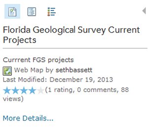
There are three buttons (or tabs) at the top of the window. The first one gives you information about the map,
the second lists the contents of the map and the third shows the legend. You may have to toggle between the second
and third buttons to get the legend symbology to show correctly (this is an ArcGIS online quirk). If you click on
the “more details” link it will take you to a page with more information about the map and some simple instructions
about identifying projects. If you select the legends button you will get a window like the one below (if you don’t
see any symbols click on one of the other buttons and then the legend button again).

If you would like to know more about a project simply click on one of the symbols in the map (see below).
A window will pop up with information about that particular project. A large orange box (polygon) represents the
FGS statewide current projects. When you select a local (or regional) project in the map, ArcGIS online will automatically
select all of the statewide projects since they contain the area of the local or regional features. Therefore, after selecting your
local (or regional) project of interest, check the blue section at the top of the information window. The blue section will
say 1 of 7 (depends on number of statewide current projects) and have an arrow indicating that you can scroll through these other choices.
The 6 other choices are the statewide projects. You can also click anywhere within the orange box that doesn't contain a point or regional
polygon to obtain just the statewide project information. 
| 





 2012 State of Florida